N°. 1 Lac de Machilly (car park on the south side): On exiting the car park, turn left towards the village, go back up the Route des Framboises and take the road leading to Bons-en-Chablais. Cross the D903. Take the Route de Borringes, then the Chemin du Chamenard which turns into a dirt track and continues as far as Chamenard.
N°. 2 Continue climbing on the surfaced Chemin du Sauget.
N°. 3 Turn right along a fairly steep path which brings you out at the bottom of the pastureland of Le Sauget. Go up until you reach the farm of Le Sauget on your right.
N°. 4 Following a treelined path, bear right as you leave the pastureland, cross a stream and go into the wood to pick up a forestry road. Go up this road and after an open section, take a path on your left, cross another forestry road and you will come to the Maison Forestière de la Servette.
N°. 5 Continue until you reach another forestry road, then turn left. A few more zigzags will bring you to the ridge. (GR Balcon du Léman long distance path). Go left and follow the Grande Randonnée (long distance path). At the Signal des Voirons (altitude 1480 m), continue along the ridge, which has some steep downhill sections, until you reach the chapel.
N°. 6 Go past the front of the chapel and down a few steps, still on the GR long distance path, cross the clearing of La Moutionnière, cross the forestry road. At the bottom of a short precipitous stretch, turn right onto a forestry track. On exiting the wood, turn right, then left and left again; the road is surfaced from here on and leads to the hamlet of "Les Granges" at the foot of the "Tour de Langin" (Tower of Langin). In the hamlet, turn left between the houses and follow the surfaced road straight ahead. The route goes round a house, at the first left-hand bend head back to Chamenard. Return to the departure point, the Lac de Machilly.
- Sport
Le Signal des Voirons
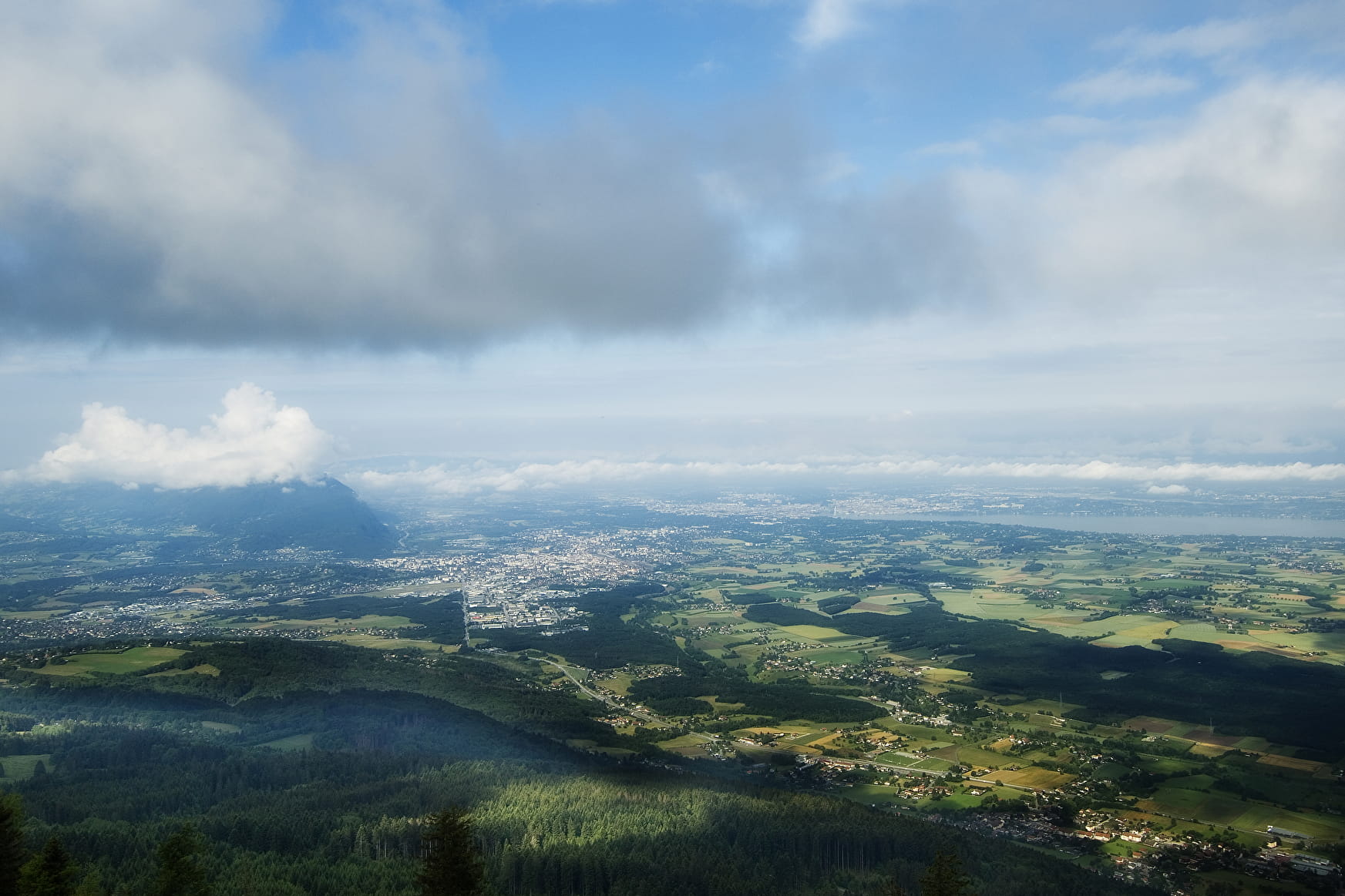
This trail, which has fairly steep gradients, will take you from the Lac de Machilly to the Signal des Voirons, the highest peak of these mountains at 1480 m.
About

Signs
PDIPR signs (yellow) along the whole route, as well as GR signs (white/red) between no.7 and no.10.


Prices
Free access.
Reception
Classified as a Natura 2000 site, Les Voirons are an outstanding, protected area. It should be treated as a fragile place, which is home to some exceptional flora and fauna.
Make sure that you are properly equipped (appropriate shoes and clothing, water, etc.) before attempting these trails. Check the weather forecast before you leave. Do not attempt trails which are classed as difficult if you have young children with you.
Period of practice
From 01/04 to 31/10.
Subject to favorable weather.
Contacts
Access
Bus : 6 - stop: Machilly Gare
Join Machilly and Lac de Machilly north east of Annemasse in the direction of Thonon (D1206) - Parking: Lac de Machilly, parking on the south side.
2nd start from Chenevard carpark

