From the Chenalette car park, take the GR de pays du tour du Mont Thabor, following the signs for the Notre Dame des Neiges chapel, which is reached in about an hour and a half.
Continue on this path, which gently climbs up the wide Neuvache valley, until you reach the rock called "Pierre du Déjeuner", an ideal place to have a bite to eat before starting the serious stuff.
You have to leave the GR de pays about 400 metres after the Pierre du Déjeuner, at the level of a grassy ridge that is easy to spot on the left. Start of the off-path.
Climb this grassy ridge, then the stony ground (quite stable and not too steep) that follows it, first heading East-North-East until you reach the rocky prominence marked 2872, which you walk around, then due North. You can aim for what, from below, appears to be a cairn marking the Passage du Pic du Thabor (2952 metres). In fact, it is not a cairn, just a rock... But when you reach it, you have indeed reached this pass.
From the Passage du Pic du Thabor, head northeast to climb the Pointe de Terre Rouge, bypassing the rocky escarpments. Still no trail (at least, I didn't see one), but we don't really need it.
From the summit, there is a beautiful view on the West face of the Pic du Thabor and on the Vanoise massif... Well, when the weather is good... Which was not the case for me, unfortunately.
Descend towards the pretty lakes located just below the Passage du Pic du Thabor. From the northernmost of them, it's easy: just follow the small stream that flows out of it, until you reach a larger torrent, oriented South-North, which you also have to follow, on slopes that are less and less inclined.
At a nice flat spot where the greenery is back, this torrent, joined by the one that descends from Lac Pépin, turns east. From there, you can see the path leading to the Marches refuge (this is, once again, the GR of the Tour du Mont Thabor).
Just in front of the refuge, you reach the footbridge that marks the beginning of the ascent to the Marches pass... The ascent is sometimes a little steep, but magnificent, especially when you overlook the unnamed lake, number 2508 (Lac du Jeu ?).
After the pass, from where you can see the Lac de Roche Noire, you have to descend about 200 metres and leave the GR de pays again to reach this lake, along a well-marked path which then crosses the Petit Fourchon ridge and descends to the Vallon and La Losa sheepfolds.
At La Losa, the loop is complete: you find the path from the start. Turn right towards the Chenalette.
- Sport
Pointe de Terre Rouge par le passage du Pic du Thabor et le col des Marches
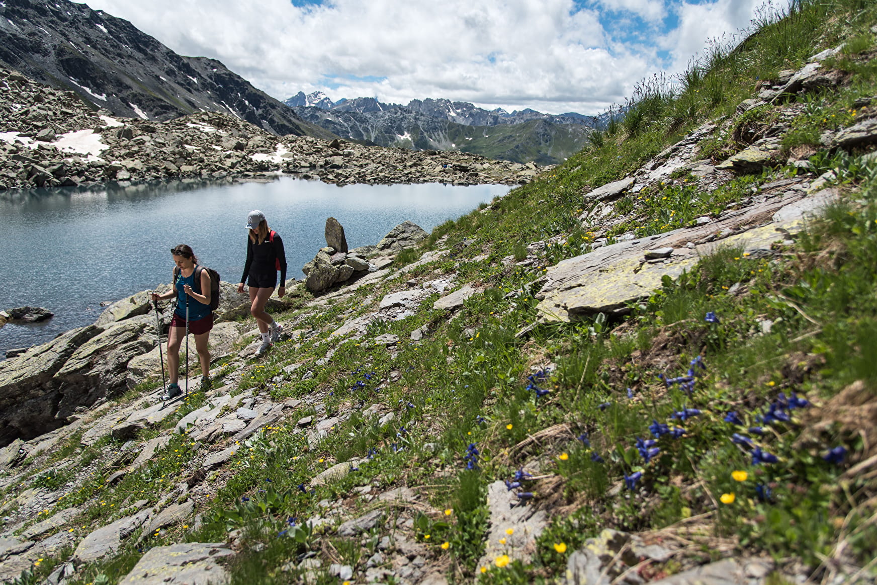
The proposed circuit varies the atmosphere, passing from the green Neuvache valley to the harsh minerality of the coombs dominated by the Pic du Thabor and the Cheval Blanc, before climbing the wild slopes of the Col des Marches. A marvellous experience!
About

Signs
GR de pays du tour du Mont Thabor (yellow and red markings + multiple signs) to the Pierre du Déjeuner. Then off-trail for the summit and the descent to the Bataillères lake, where you find the same GR leading to the Marches pass. Thereafter, a good well-marked path leads to the Roche Noire lake and the descent to La Losa.
Prices
Free of charge.
Reception
Partly off-path and unmarked, therefore requiring a minimum sense of direction;
Quite a long hike with a significant positive difference in altitude (about 1900 metres), but it is possible to complete it in a day and a half by spending a night at the Marches refuge (in this case: 1350 metres of D+ on the first day, 550 metres on the second).
Period of practice
From 15/05 to 15/10.
Subject to snow conditions.
Subject to favorable weather.
Contacts
Access
From Saint-Michel-de-Maurienne, take the D 215a until it ends at Valmeinier 1800. After the large arched car park, turn right and then immediately right again onto the track which leads (indicated by a sign) to the Chenalette car park, the starting point of the hike.