This hike starts in the centre of the typical Haut Savoyard village of La Chapelle d'Abondance. It is located within the natural site of the Cornettes de Bise, classified Natura 2000.
You will take the road and then follow a forest path in the direction of Chevenne.
You will then take a pastoral track and a path towards the Vernaz pass at the foot of the imposing Cornettes de Bise mountain. At the pass, a magnificent view awaits you on its southern face.
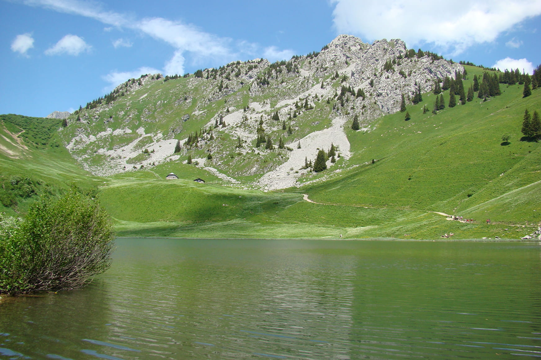
You will then reach the Col de Resse and then the Col du Serpentin and the Tête de l'Avalanche, the highest point of the route at 1854m. This viewpoint on the lake of Arvouin, the Dents du Midi and the valley of Abondance is worth the diversions.
It is also an area frequented by mouflons, marmots and grouse roosters.
After a short descent through the alpine chalets, you can enjoy a moment of relaxation at the edge of the Arvouin lake. You may meet Abondance cows or ibexes, which are very present on this site.
The return to the village of La Chapelle d'Abondance is via a fairly steep path through the Tête de la Maisonnette mountain pasture and a long descent through the forest.
- Sport
Lake Arvouin loop
A beautiful hike which starts from the centre of the village of La Chapelle d'Abondance and offers superb views of the Cornettes de Bise, the lake of Arvouin, the village and the valley of Abondance.
About

Signs
Departmental markings called P.D.I.P.R. on beige metal panel and green writing.
Difficult passages
To cross a steep passage towards the Col de Resse, you will need to use a handrail (chain) for a short distance.
Map references
Portes du Soleil hiking map in France and Switzerland TOP 25 N°3528 ET Morzine Massif du Chablais Les Portes du Soleil
Topoguides references
On sale in the tourist offices of the Abondance valley.
Further informations
Stone, Ground, Grit


0/ Start : "route de Chevenne".
1/ Take the road to "Chevenne" on foot.
2/ Follow the forest path on your left towards " Chevenne ".
3/ At the Chevenne car park, take the path on your right towards the "Col de Vernaz".
4/ Once at the pass, turn right towards the "Col de Resse" and the "Tête de l'Avalanche".
5/ After reaching the "Tête de l'Avalanche", go down the path towards the "lac d'Arvouin". Rejoin the road that runs alongside the lake.
6/ The return to the village of La Chapelle d'Abondance is done by the path starting at the level of the outlet of the lake and going down through the "Alpage de la Maisonnette".
7/ The itinerary is not recommended without suitable equipment if there is still snow, as the passages in the corridors and on certain slopes are very exposed.
Prices
Free access.
Reception
Dogs must be kept on a leash because of the presence of herds, Natura 2000 reserve.
Period of practice
From 01/06 to 30/09.
Accessible except during snow and depending on weather conditions.
Please check with the Tourist Office for the latest information on access conditions. This route is usually suitable for strong walkers during spring, summer, and autumn, except in adverse weather.
- Pets welcome
- Picnic area
- Parking nearby
Contacts
Access
Free parking under the tourist office or access to the starting point by shuttle (municipal in winter or line C and line 12).

