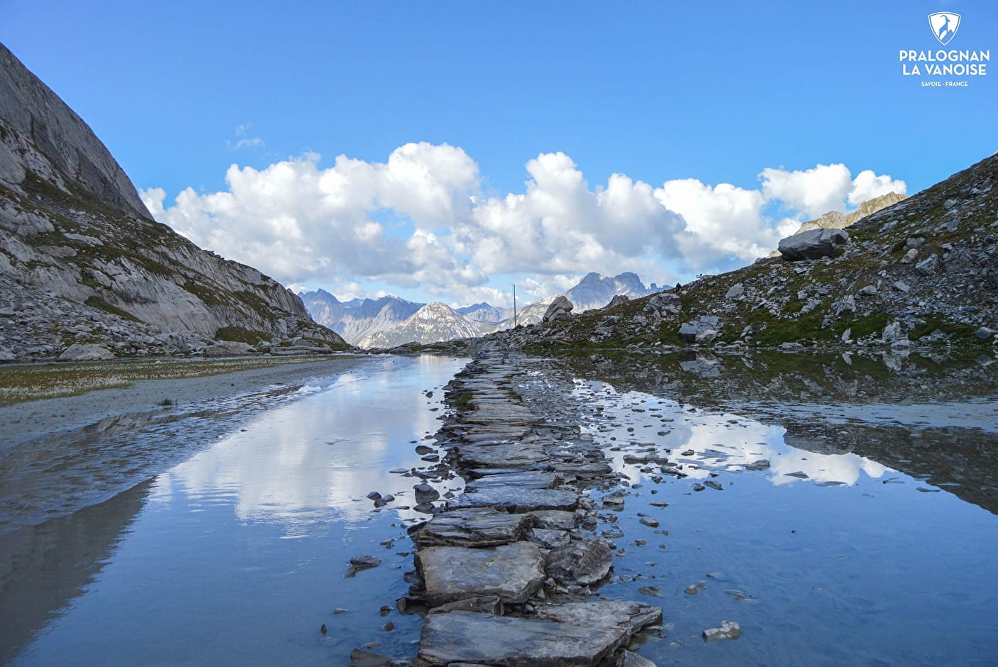
After walking along the drystone walls, renovated in 2004 and 2005, that once marked the salt and tomme route, you ford the Lac des Vaches on a path of cut stones, as if by magic! An itinerary steeped in history and unquestionably one of the most one of Savoie's most beautiful hikes of its highest point: La Grande Casse (3,855 m).
- Sport
Lac des Vaches - Col de la Vanoise
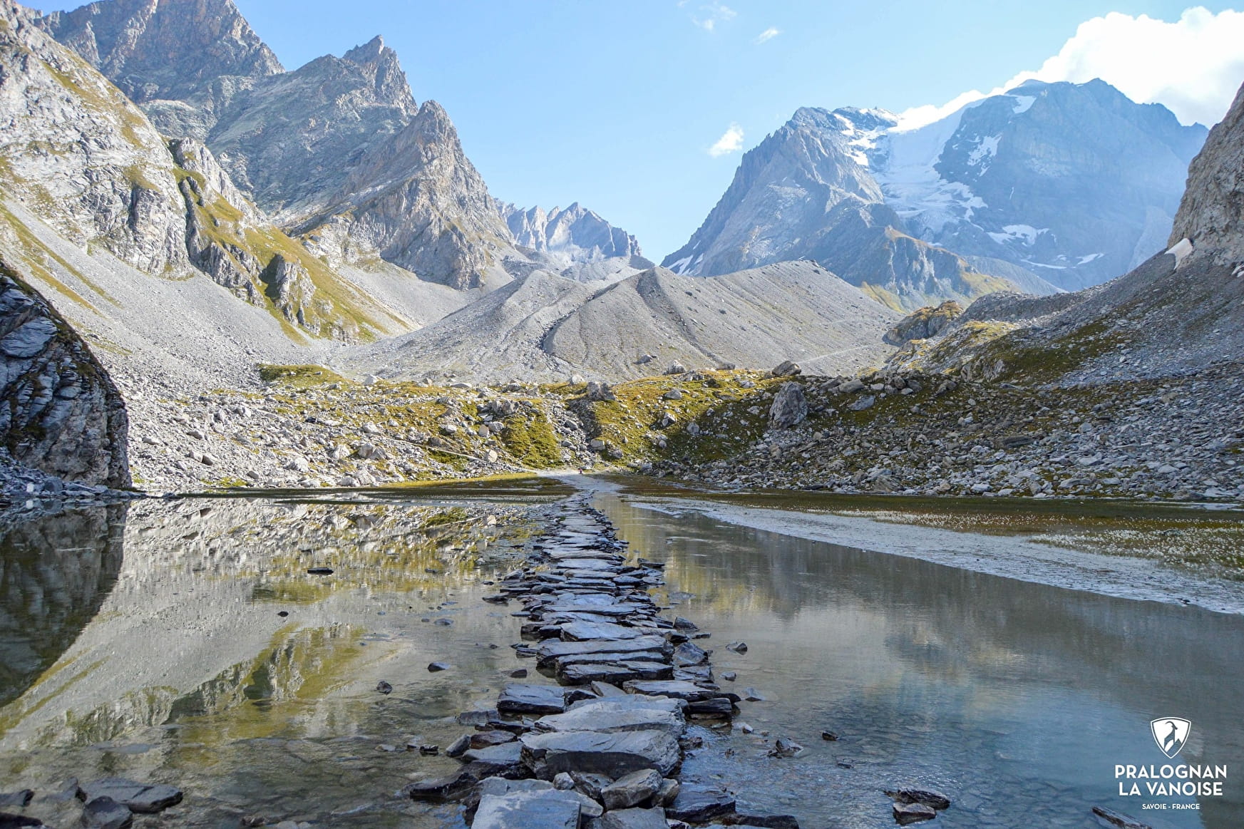
Can you imagine walking on the water of a high mountain lake? Can't you? Then cross Lac des vaches, hopping across the stone slabs against the majestic backdrop of the most beautiful peaks in the Vanoise.
Sport Lac des Vaches - Col de la Vanoise Pralognan-la-Vanoise
About

Further informations
Rock, Stone, Ground, Grit
1 3


It's possible to take the Genépi chairlift to save money and reduce walking time.
1h30 (depending on opening conditions).
1. From the Les Fontanettes parking lot, take the GR 55 forest path alongside the ski slope to the Barmettes refuge (path no. 13).
2. Continue along the path lined with low dry-stone walls (path no. 14) to reach the Lac des Vaches flat.
3. On the way down, follow the same route.
VARIATION: COL DE LA VANOISE (2,515 m) (very easy) +2h, +200 m ascent, +4.5 km round trip
(in addition to the main itinerary)
The Col de la Vanoise, and more specifically the Col de la Vanoise refuge, is a major mountaineering destination. The historic refuge (formerly Félix Faure) dates back to 1902 and was completely renovated in 2018. To meet new reception standards, a new building was erected on the site in 2013. The refuge offers a breathtaking panorama with the backdrop of the Grande Casse, Glières, Réchasse and Aiguille de la Vanoise. The refuge is a stopover point on the Tour des Glaciers de la Vanoise and the Tour de la Grande Casse.
Follow the previous itinerary to stage 2.
1. Continue on the trail up the moraine of the Grande Casse glacier (trail no. 14), fording the lake on the slabs.
2. Continue along Lac Long to the Col de la Vanoise refuge.
3. For the descent, follow the same route.
Optional: from the refuge you can reach Lac Rond (10 min).
ALTERNATIVE LOOP ITINERARY : COL DE LA VANOISE (2,515 m) PAR LE SENTIER DES AROLLETS (difficult) +5h30, +890 m ascent, +12km, From mid-June (snow) to end of September
This red route is recommended for good uphill walkers.
1. From the Les Fontanettes parking lot, head for the cirque de l'Arcelin (trail no. 21).
2. In the cirque, take the Arollets path on your right (path no. 24) (note: in the first combe, take the left-hand fork) and continue to the Col de la Vanoise refuge.
3. On the way down, follow the Lac Long, ford Lac des Vaches and join the Barmettes refuge (path no. 14).
4. From the Barmettes refuge, take the forest path alongside the ski slope (path no. 13) to the Fontanettes parking lot.
Another loop variation: from Chalet de la Glière, you can reach the upper part of the Arollets valley via Pas du Moriond.
Prices
Free access.
Reception
Period of practice
From 01/06 to 16/10.
Subject to favorable snow and weather conditions.