(1) From the car park, you reach the Croix du Rocher, which marks the start of the GR9, towards the Fort du Saint-Eynard. The marked trail (red and white) crosses
a small torrent and then joins the acrobatic park, where you take a path that joins the alpine ski slopes. The climb to the ridge is done by these
tracks. The GR leaves the track and branches off to the left just before going up on the ridge. (2) End of the difficulties: the rest of the course is relatively flat and straight.
After Pas Guiguet, we arrive at the old batteries and then at the fort. For the most beautiful point of view on Grenoble, continue the GR which circumvents the ditch and goes up to a platform offering a clear panorama (3). (4) To make a loop towards the Sappey, return to the end of the old batteries and locate the start of the yellow marked path, which descends through the woods, crosses the road several times and
leads back to the hamlet of Pillonières. From there, you reach La Faurie then the path leads back to the Acrobatic Park.
To see / to do near the route:
• Petits Jardiniers (10 km from the start): cultivation of medicinal plants.
• Arcabas en Chartreuse Museum (13 km from the start): Church of St Hugues.
• Badiane Créations (14 km from the start): clothing creations.
• Musée de la Grande Chartreuse (15 km from the start): audio-guided tour.
All the information and other ideas for visits on chartreuse-tourisme.com/rsf
Information / security:
- you should adopt a few rules and follow a few tips to fully enjoy your walks and hikes in complete safety! Before leaving, follow our recommendations and advice on chartreuse-tourisme.com/conseils-rando-trail (or on request at the tourist offices).
- Note: the mountain guide is a specialist in mountain fauna and flora, off-trail hikes away from the crowds, local history, alpine and peasant traditions, etc. safely ! Call on them! Detailed list on chartreuse-tourisme.com/accomp (or in tourist offices)
- Sport
Crêtes du St Eynard
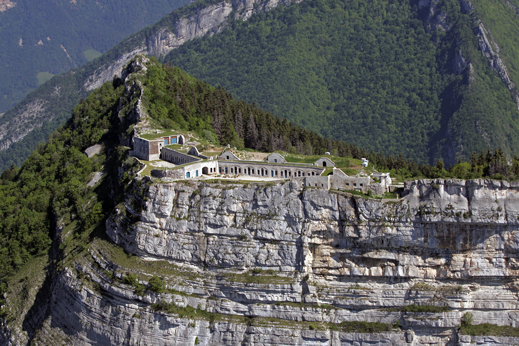
A loop to admire one of the most beautiful points of view on
Grenoble and discover the fort, perched at 1338m, built between
1873 and 1879 to protect the city from aggression since the
valley as from the mountain - yet it has never been used!
Sport Crêtes du St Eynard Le Sappey-en-Chartreuse
About

Prices
Free of charge.
Reception
Period of practice
From 01/05 to 30/11.
Services
- Pets welcome