
Counter-clockwise route
Allow between 8 to 15 days to explore the French, Italian and Swiss Alpine valleys. You will have many options of lodging in shelters or lodges throughout this tour. The tour outlined below describes the stages in the high mountains of Savoy, from the Col de Balme to the Col du Bonhomme. You will discover many glacier panoramas and will pass through nature reserves, with landscapes changing over the altitudes
Car access
From Chamonix, pass the village of Argentière, park at the Col des Montets car park, near the Chalet Reserve
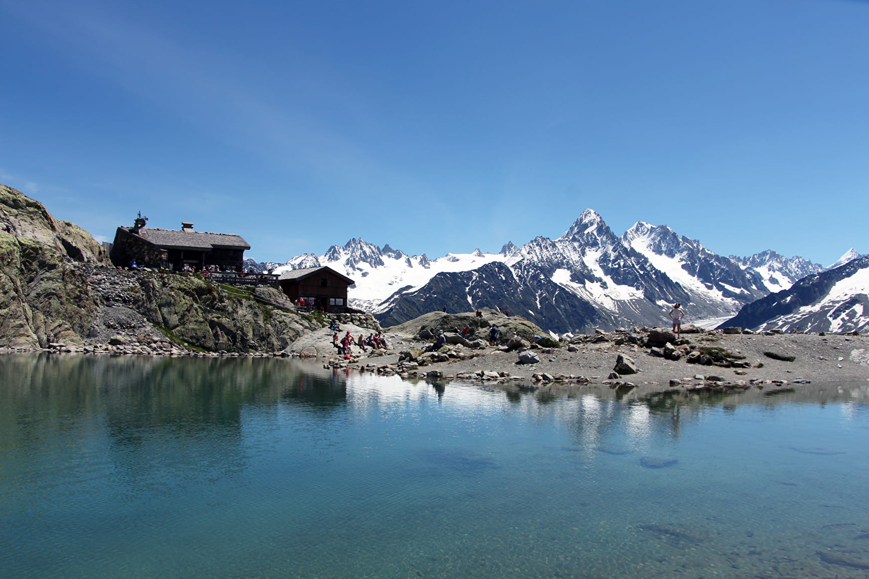
Stage 1: Col des Montets (1,461 m)/Chalet Lac Blanc – 2,358 meters
Col des Montets (1,461 m) - Lac Blanc Refuge (2,358 m): 3 hrs 15 min.
Stage 2: Lac Blanc Hut/Bel Lachat Lodge – 2,166 meters
Lake Blanc Hut (2,358 m) - Planpraz (1,995 m): 2 hrs 50 min
Planpraz - The Brévent (2,525 m): 1 hr 45 min
Brévent - Bel Lachat Lodge (2,166 m): 1 hr
Step 3: Bel Lachat Lodge (2,166 m)/village of Les Houches (1,014 m)
Bel Lachat Lodge (2,166 m) - Merlet Park (1,480 m): 1hr 45 min.
Merlet Park - Les Houches (1000m): 1 hr 15 min
Stage 4: Les Houches (1,000 m)/Contamines Montjoie (1,170 m)
Les Houches (1,000 m) - Fioux Lodge (1,449 m): 2 hrs 10 min
Fioux Lodge - Champel Hostel (1,205 m): 1 hr 10 min
Champel Hostel - Les Contamines (1,187 m): 1 hr 45 min
Stage 5: Contamines Montjoie (1449 m)/Lodge at the Col de la Croix du Bonhomme (2,443 m)
Contamines Mont-Joie Tourist Office (1,449 m) - (1,210 m): 1 hr 50 min
Our Lady of the Gorge – Balme Lodge (1,706 m): 45 min
Balme Lodge - Col du Bonhomme (2,329 m): 1 hr 30 min
Bonhomme Pass - Croix du Bonhomme hut (2,443 m): 45 min
Stage 6: Bonhomme Cross Lodge (2,443 m)/Elisabetta Lodge - Italy (2,168 m)
Bonhomme Cross Lodge (2,443 m.) - The Chapieux (1,554 m): 1 hr 50 min
The Chapieux - Glacier City (1,789 m): 1 hr 30 min
City of Glaciers - Col de la Seigne (2,518 m): 2 hrs 50 min
Col de la Seigne - The Lower Alps of the White Lily (2,285 m): 50 min
Lower Alps of the White Lily – Elisabetta Lodge (2,168 m): 10 min
Stage 7: Elisabetta Lodge (2,168 m) - Courmayeur (1,226 m)
Elisabetta Lodge (2,168 m) - Lake Combal: 30 min
Lake Combal - Arp Upper Town (2,303 m): 1 hr
Arp Old Lake Checroui (2,165 m): 1 hr 20 min
Lake Checroui - Courmayeur (1,226 m): 1 hr 30 min
Step 8: Courmayeur (1,226 m) - Bonatti hut (2,025 m)
Courmayeur (1,226 m) – Bertone Lodge (1,989 m): 1 hr 35 min
Refuge Bertone - Bonati Lodge (2,025 m): 2 hrs 15 min
Step 9: Bonatti Lodge (2,025 m) - La Peule chalet (2,071 m)
Bonatti Lodge (2,025 m) - Arp Nouva Desot (1,776 m) (or Arnuva): 1 hr 30 min
Arp Nouva Desot (or Arnuva) – Héléna Lodge (2,054 m): 1 hr
Héléna Lodge - Grand Col Ferret (2,537 m): 1 hr 40 min
Grand Col Ferret - La Peule chalet (2,071 m): 1 hr 5 min
Stage 10: La Peule chalet (2,071 m) - Champex-le-lac (1,460 m)
La Peule chalet (2,071 m) - Ferret (1,705 m): 45 min
Ferret - Fort Praz (1,151 m): 3 hrs
Fort Praz - Champex le Lac (1,460 m): 2 hrs
Stage 11: Champex-le-lac (1,460 m) - Trient (1,297 m)
Champex le Lac (1,460 m) - Bovine (1,975 m): 3 hrs 40 min
Bovine - Col de la Forclaz (1,526 m): 1 hr 30 min
Col de la Forclaz - Trient (1,297 m): 30 min
Stage 12: Trient (1,297 m) - Col des Montets (1,461 m)
Trient (1,297 m) - Herbageres (2,036 m): 2 hrs 15 min
Herbageres - Col des Posettes (1,997 m): 55 min
Col des Posettes - Col des Mottets (1,461 m): 2 hrs
- Sport
Classic 12-day Tour of Mont Blanc
Iconic itinerary, the tour of Mont Blanc goes through three countries and offers a variety of alternative routes.
Sport Classic 12-day Tour of Mont Blanc Argentière
About
Signs
Departmental signposting / Espace Mont Blanc, Switzerland and Italy
Difficult passages
Depending on the weather conditions, some passages may be difficult.
1 10


Prices
Free of charge. There is no fee for the tour itself, but there are charges to pay for accommodation (cottages, shelters, hotels) and services (professional alpine guide). Bivouacs are prohibited outside the reserved sites. (See Tourism Offices and/or Lodges).
Reception
Period of practice
From 15/06 to 30/09.


