


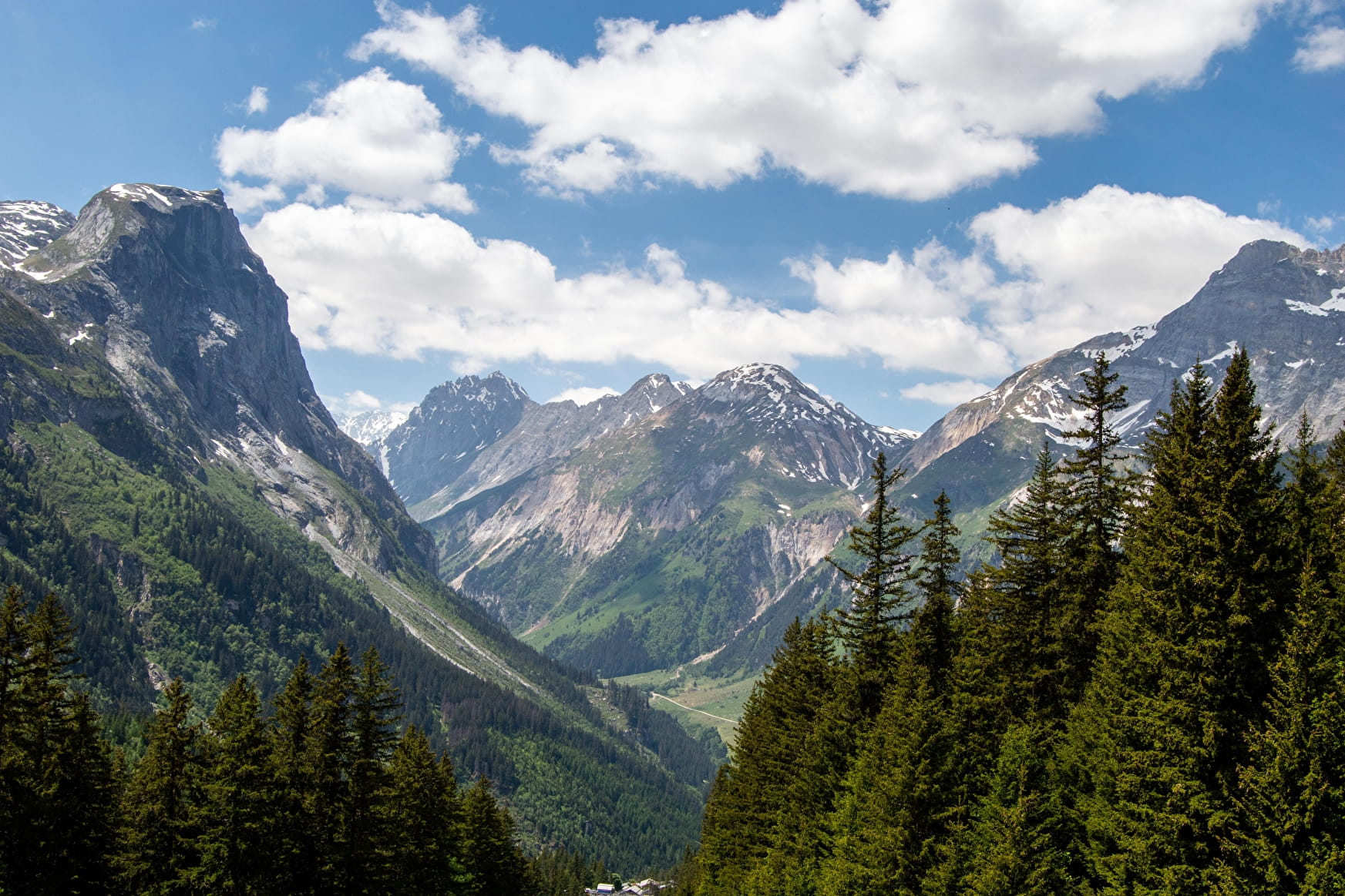
You'll set off on a varied route between forest and high mountain.
It's an easy start from the Fontanettes car park, and you'll soon take a small forest path that will lead you to the enchanted forest of the Bois de la Glière... This path winds its way between large moss-covered boulders, inviting you to look up at the treetops, walk through the fir cones or touch the bark of the trees.... Suddenly the forest comes to a halt and you come to a platform that invites you to look up at the summit of Pointe du Dard, from where avalanches can sometimes be quite impressive!
The path continues into the cirque de l'Arcelin, a natural amphitheatre offering a breathtaking view of the great vertical walls of Moriond, the Aiguilles de l'Arcelin and the Grand Marchet.
Then take the path known as "Les Arollets" to the right of Moriond. You will then quickly ascend, along a sometimes technical path, towards the Lac des Assiettes plateau and then the Col de la Vanoise refuge.
The refuge offers a unique view of the Grande Casse and its glacier, the Arête de la Réchasse, the Grande and Petite Glière... Here you can enjoy a good night's rest after tasting the keeper's delicious dishes.
The second day is a magnificent descent through the glacial moraine. You'll skirt around the Aiguille de la Vanoise while skirting Lac Long at the foot of the Grands Couloirs... You may be lucky enough to spot ibex, chamois or marmots.
Then comes the crossing of Lac des Vaches... Imagine jumping from rock to rock, walking on water, in the majestic setting of the most beautiful peaks in the Vanoise.
The trail continues through the mountain pastures as far as the Barmettes refuge, then you can follow a path through the forest along the Couloir de l'Eau trail as far as the Fontanettes car park.
- Sport
2-day itinerant hike: Tour of the Aiguille de la Vanoise
A beautiful 2-day itinerary between glaciers and mountain lakes. Imagine jumping from rock to rock to cross Lac des Vaches in the majestic setting of the most beautiful peaks in the Vanoise.
About

Signs
Yellow signs
Map references
TOP 25 IGN 3534OT
Topoguides references
PRALO RANDO hiking itineraries, sold at the Pralognan Tourist Office: 12 euros Topo to download from the website: https://www.pralognan.com/prestataire/lac-des-vaches-col-de-la-vanoise-874026/?r=456
Further informations
Stone, Ground


Start: Les Fontanettes car park 1640m 1/ DAY 1: From the Les Fontanettes car park to the Col de la Vanoise refuge/ Time: 3h/ Ascent: +877m/ From the Les Fontanettes car park, take the 4x4 path that leads off to the right of the Genépi chairlift. After a few minutes' walk, take the path on the left, which leads into the Glières forest (the playful "lutin" path), as far as the Arcelin cirque. Then take the path known as "les Arollets", to the right of Moriond, which will take you to the Col de la Vanoise refuge (red path).
2/ DAY 2: From the Col de la Vanoise refuge to the Fontanettes car park/ Time: 2h30/ Ascent: -877m/ Descend from the refuge along the GR 55, which runs alongside Lac Long, at the foot of the Grande Casse. You will skirt around the Aiguille de la Vanoise. The path continues through the moraines as far as Lac des Vaches, which you cross on beautiful flat stones. The path continues through the alpine pastures to the Barmettes refuge, where you can follow a path to the left through the forest along the Couloir de l'Eau track to the Fontanettes car park.
Prices
Free access. Fee-paying huts. During the period when the refuge is guarded, meals are available in addition to the overnight stay. When the hut is not guarded, the price of the night is compulsory.
Reception
Drinking water points in the Fontanettes car park, at the Col de la Vanoise and Les Barmettes huts.
Rules in the heart of the Vanoise National Park:
- Do not bring dogs, even on a lead
- Do not pick or take any flowers, fruit, insects or minerals
- Take away all your rubbish
- Do not disturb the tranquillity of the area or the wildlife by noise, shouting or sound equipment
- Do not camp or bivouac EXCEPT near certain refuges
- Do not light fires
- Stay on the paths and avoid cutting the paths when descending
- Do not practice paragliding or other aerial sports
- Do not mountain bike
- Do not use motorised vehicles
Period of practice
From 01/06 to 21/09/2024.
Guarded refuge.
- Coach access
- Motorhomes allowed
- Restaurant
- Covered picnic area
- Car park
- Public WC
- Play area
- Picnic area
Contacts
Access
From the village centre, follow the signs to the Fontanettes car park by the road.
A free shuttle bus runs from the village centre to the Fontanettes car park in July and August.


