


As you make your way along the path through the high-altitude meadows,
you'll come across alpine chalets with unique shapes. These chalets are
designed to withstand avalanches, with some being semi-buried or protected
by a "tourne," which is a stone prow. Amid the glaciers of Albaron, Vallonnet,
and Evettes, you make your way along this breathtaking trail that overlooks
the Sources de l'Arc cirque. You pass a number of lakes and the views never
cease to amaze you. Azures and turquoises unfold before your eyes, in a
stunning parade of shades of blue. A few chamois can be seen in the distance.
You get to the refuge, see how perfectly it blends into the rugged background
of the mountains. Check out the view of the lakes from above. It feels like
you're at the end of the world! This is a dream opportunity to spend a night
under the stars and the crystalline sky of the high-altitude mountains. Make
a wish for every shooting star!
On your way down, take some time to visit the hamlet of l'Écot and Bonneval-sur-Arc. Isn't that Sebastian who running down an alley, followed by his
faithful Belle?
103 - Balcon et Refuge du Carro
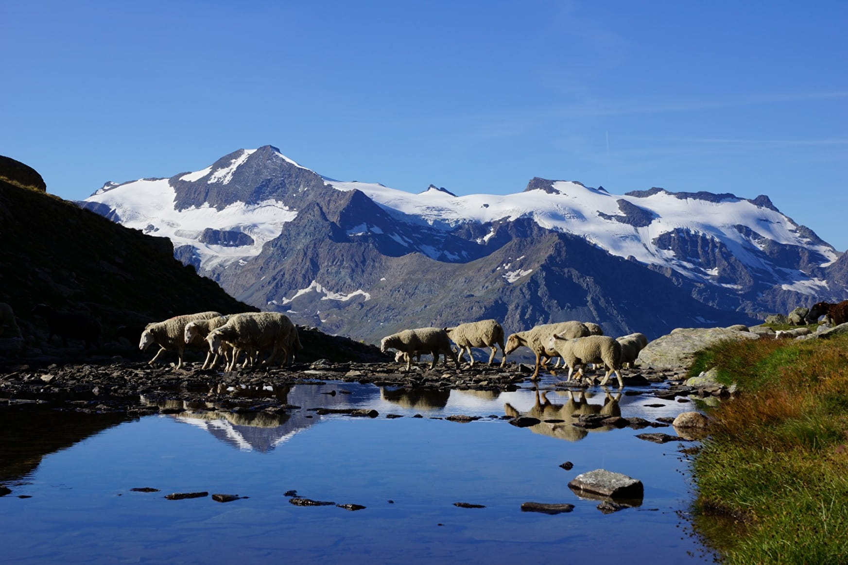
This stunning mountain trail offers amazing views of the Albaron, Vallonnet and Evettes glaciers, their reflections mirrored in the surrounding mountain lakes. The shades of blue, from azure to turquoise, are always surprising.
About
Signs
directional signs and cairns
Map references
TOP 25 IGN - 3633 ET- Tignes-Val d'Isère / Haute-Maurienne Map and booklet "Balades et Randonnées Haute Maurienne Vanoise" (sold at 10 € in the Tourist Office)
Topoguides references
TopoGuide "Savoie Mont Blanc on foot Black route n°103
Further informations
Rock, Stone, Ground


0/ : Parking at the Oulietta bridge (on the road to the Col de l'Iseran). It is possible to go up by shuttle (July and August) from Bonneval sur Arc (ask at the Tourist Office).
1/ : From the car park, the balcony path goes east towards the Carro refuge.
2/ : The path crosses large mountain pastures where flocks of sheep graze, with a breathtaking view of the glaciers of the sources of the Arc and the North faces of the Charbonnel and Albaron.
Continue past the Plan des Eaux lake towards the Pys lake.
3/ : Pass near the lake of Pys at the foot of the Ouille des Reys.
4/ : Leave on the right the path that you will take on the way back to Ecot and Bonneval sur Arc and continue to the Carro refuge surrounded by the Lac Noir and Lac Blanc.
5/ : Mineral atmosphere at the highest refuge in Savoie. Possible stop or night before going back down to the valley.
6/ : Take the path on the left to return to the hamlet of Ecot. A beautiful descent of about three hours.
7/ : Cross the hamlet of l'Ecot and join Bonneval sur Arc by the bucolic Agneaux path along the Arc.
8/ : From the Tourist Office, you can take the shuttle (or hitchhike) to the Pont de l'Oulietta to pick up your car. If, on the outward journey, you left on foot using the shuttle, then you have arrived!
Prices
Free access.
Reception
Period of practice
From 15/05 to 15/10.
Accessible outside the snowy period and depending on the weather conditions. Please contact the Tourist Office beforehand to find out the current access conditions. Recommended season: spring - summer - autumn.
Subject to favorable snow and weather conditions.
Contacts
Access
Car access and parking: Park in Bonneval near the Tourist Office car park. Take the shuttle bus (see timetable at the Tourist Office) towards the Col de l'Iseran. Get off at the Oulietta bridge (start of the hike).
Map : IGN map : Top 25 - 3633 ET Tignes Val d'Isère


