Mont de Grange is a 3,000-hectare nature reserve, classified Natura 2000. It's also a hunting reserve where deer, chamois, roe deer, mouflons, marmots, black grouse, ptarmigan and golden eagles live side by side... You can easily observe them early in the morning.
This hike also invites you to discover wild flora such as martagon lily, paradise lily, alpine columbine, gentian and genepi.
This challenging hike starts at Saint Théodule, Follebin in Abondance. You'll walk alongside the Chapelle Saint Théodule.
You then head for the Bailly and Jouly mountain chalets, on a carriage road overlooking Lac des Plagnes, with a magnificent view of Entre-Deux-Pertuis and Roc de Tavaneuse.
You'll then reach the Lenlevay chalets, where Abondance cows graze on the mountain pastures during the summer season.
You then take the GR5 path towards La Chapelle and the Crête de Coincon, a fairly steep path that leads to the summit of Mont de Grange. An orientation table shows you the various peaks of the French and Swiss Alps and the Jura.
Alternative: the climb can also be made from Pré la Joux in Châtel.
- Sport
Hiking Mont de Grange (Return) - Abondance
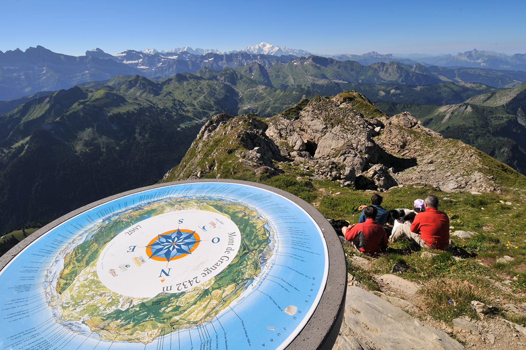
The Mont de Grange (2432 m) is one of the most famous of the Massif du Chablais. At its summit, you will discover a view on the whole valley of Abondance, the mountains of the region, the lake of Geneva and the Mont-Blanc.
About

Signs
Departmental signposting called P.D.I.P.R. on beige panel and green lettering
Difficult passages
Just before the top.
Map references
Portes du Soleil hiking map in France and Switzerland TOP 25 N°3528 ET Morzine Massif du Chablais Les Portes du Soleil
Topoguides references
On sale in the tourist offices of the Abondance valley.
Further informations
Rock, Stone, Ground


0/ Car park of "Saint Théodule" at "Follebin" in Abondance.
1/ Follow the path that leads to the Saint Théodule chapel and then take the direction of the "Chalets de Bailly" and the "Chalets du Jouly" by a carriage road.
2/ Then join the chalets of "Lenlevay".
3/ Take the path that goes up on the left, it is the GR5 in the direction of the "Crête de Coincon".
4/ After about 200 metres, take the path that goes up in the forest on the left "Crête de Coincon".
5/ Follow the path along the ridge, it will lead you to the top of the Mont de Grange.
Prices
Free access.
Reception
Dogs must be kept on a leash (Natura 2000 reserve zone) and hunting reserve.
Period of practice
From 01/06 to 31/10.
Subject to favorable weather.
- Pets welcome
- Orientation board
Contacts
Access
The departure is in Abondance, in the center of the village, take the direction of the lake of Plagnes. On the road, after a big bend, turn left towards Follebin. Go up a small winding road. You will reach a road that can be driven on, continue until you reach a small parking lot.

